Ecological connectivity can be defined as the degree of connection between the various natural environments present within a landscape, in terms of their components, spatial distribution and ecological functions.
The landscape is composed of a dynamic mosaic of natural and humanized patches. Over the years, the landscape has been modified and fragmented by development. To offset the negative effects of fragmentation of natural habitats, conservation biologists have advised increasing connectivity between habitats. The conservation of natural corridors between habitats is essential to sustain biological diversity in a changing climate and to ensure the maintenance of ecological services to the community.
Why care about natural environments and their connectivity?
Did you know that maintaining and restoring ecological connectivity is a well known strategy for adapting to climate change?
Natural environments are at the service of your fellow citizens and you can make a real difference in the well-being of the population by promoting connectivity.
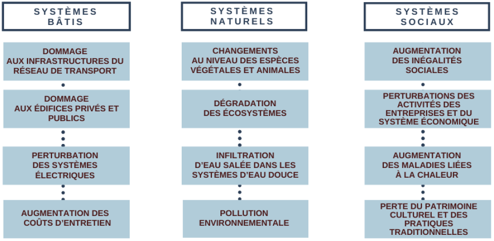
The impacts of climate change that you are (or will be) facing are felt in constructed systems, natural systems and social systems. It is therefore important to be adequately prepared to deal with these impacts.
You can take concrete action to address these issues through land use approach that takes into account the ecological services provided by nature!
Climate change adaptation includes any action or measure that can help you adapt to the observed or predicted climate and its collateral impacts. This can include planning for major storms, improving the capacity of stormwater management systems, encouraging green space in urban areas, etc.
"The goal of adaptation is to better manage and reduce your vulnerability to the harmful impacts of climate change, whether it is rising sea levels, increased frequency and severity of extreme weather events, water scarcity or food insecurity."
- Municipal Climate Services Advisory Committee (MCSAC), 2020
To learn more about climate adaptation in the context of local government decision-making, see Let's Talk - A Discussion Guide for Local Governments on Climate Change Adaptation (link in french), produced by the Municipal Climate Services Advisory Committee (MCSAC), a joint initiative of the Federation of Canadian Municipalities (FCM) and the Canadian Centre for Climate Services (CCC).
We are all intimately linked to the natural environments that surround us. Let's just think of the well-being provided by a stay in nature, whose benefits on physical and mental health are widely documented.
Pensons aussi aux milieux humides qui agissent comme des barrières naturelles lors des crues des cours d’eau. De véritables éponges! Let's also think about the wetlands that act as natural barriers during river floods. They are like sponges! The preservation of these natural environments helps reduce the impact of flooding. According to Urgence Québec, at the height of the 2017 floods, 261 municipalities were affected, 5,371 homes flooded, 4,066 people evacuated and nearly 400 roads damaged. The costs for this flooding episode amounted to $360 million for the Quebec government alone.
Natural heritage is suffering heavy losses throughout the world, and Quebec is no exception to this trend. The destruction of natural environments leads to increasing pressure on biodiversity and, consequently, to major impacts on humans. All of this has ever-increasing costs...
These tensions result in :
- the degradation of surface water quality, leading to more expensive pre-consumer treatment or forcing the restriction of recreational activities;
- increasingly frequent smog episodes in southern Quebec, with a direct impact on the respiratory health of citizens;
- the considerable decrease in the number of pollinating insects, an essential link in the productivity of crops;
- the drop in fish stocks, necessitating the imposition of moratoria on fishing;
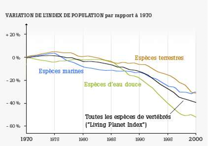
- a loss of global biodiversity;
To learn more about the global assessment of biodiversity and ecosystem services, see the Summary for Policymakers (link in french) produced by the Intergovernmental Science-Policy Platform on Biodiversity and Ecosystem Services.
We inherit the decisions of the past, but we have the opportunity to act with the knowledge of the present!
Natural environments are increasingly fragmented, which is even more detrimental to the maintenance of biodiversity and the ecological services provided.
Composed of four types, these essential services provided by nature can hardly be substituted, except at very high costs, when they are altered by human activities:
- provisioning services (e.g. food, fresh water and raw materials);
- regulation services (e.g. climate and flood regulation, pollination);
- socio-cultural services (e.g. recreation, tourism, nature-related well-being);
- supporting services (e.g. species habitats, genetic diversity, biogeochemical cycles).
As the PhareClimate platform points out, cities are struggling to reconcile socio-economic and ecosystem needs. How do we integrate ecological goods and services into municipal governance? This is where ecological connectivity comes in!
In this context, wildlife and plant species are expected to migrate to adapt to new conditions. In Quebec, this represents an average northward migration of 45 km per decade! Ecological corridors are privileged migration routes, especially where agriculture and urbanization dominate.
Researchers from the University of Washington and The Nature Conservancy have modeled the potential habitat of 2,954 animal species based on projections of climate change and the needs of each species. The result of this modeling, "Migrations in Motion," illustrates the ecological connectivity for wildlife to adapt to a warming climate.
Global warming is accelerating habitat loss, degradation or fragmentation. Maintaining connectivity between habitat cores is one of the most effective ways to protect biodiversity in this context. Just as humans depend on transportation corridors, wildlife must also move across landscapes. (Adaptation and Biodiversity Working Group, 2018)
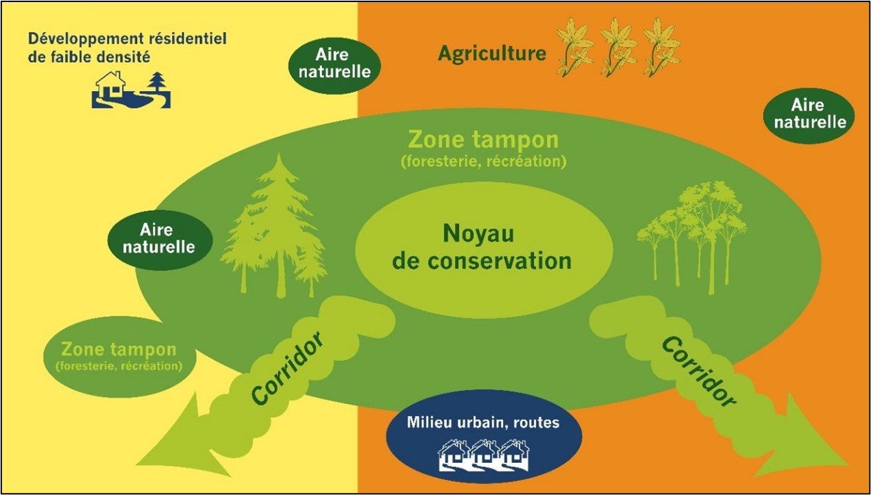
There is no doubt that it is beneficial to recognize and protect natural corridors, but what do they actually connect? The idea behind protecting corridors is to integrate a coherent and interconnected ecological network of natural and semi-natural landscape components. This network includes habitat cores, buffer zones and spatially defined corridors.
MRCs, cities and municipalities already have the planning and regulatory tools to take action!
The alliance between municipal authorities and conservation groups, who are experts in the field of natural environment protection, is often a guarantee of success and efficiency. Ask about groups in your community, and the partnerships that emerge often lead to inspiring joint projects.
The Réseau de milieux naturels protégés (RMN) is an excellent starting point for identifying the players in your region (conservation organizations, foundations, associations, etc.). The RMN has over 70 members interested in voluntary conservation on private land. In the search for allies, the watershed organizations (OBV), the regional consultation tables and the regional environmental councils (CRE) can prove to be indispensable resources.
"Alone we go faster, but together we go farther!"
Where to start?
Integrating ecological connectivity into decision-making processes can be summarized in four steps:
Step 1 - Define the Essential Prerequisites
Essential Prerequisites :
-
Set your goals! It is important to define the criteria for your community. Is your vision local or regional? Are there opportunities to be seized?
-
Connect what exactly? Habitats for a particular species or group of species, water or wetlands? Determine the key elements of the ecological network based on the elements of ecological interest in your territory.
-
Define the parameters for implementation: who are the people in your organization responsible for implementation? What deliverables are desired?
-
Ask for help: seek advice from local scientists and natural resource managers.
Make nature, biodiversity and ecological connectivity in your territory a priority from the beginning of your planning!
Step 2 - Acquire knowledge
Consideration of ecological connectivity in Quebec's municipalized areas depends largely on a good knowledge of the environment upstream of the planning and development process. Regional wetland and water plans (PRMHH) are a good example of knowledge acquisition.
Planning should be based on quality information, such as:
- Clearly establish the natural attributes your community wants to conserve (landscapes, woodlands, streams, wetlands, wilderness trails, etc.)
- Collect and compile all available relevant information on the natural features of your territory and areas of conflict between human and wildlife activities
- Identify sensitive or ecologically important elements. Government departments can assist you in this process by providing information on wildlife and plant species that have been designated as threatened or vulnerable or are likely to be so designated.
- Consult with your local organizations, conservation groups, watershed organizations, hunting and fishing groups, citizens' associations, etc.
- Participate in conservation group or academic initiatives to discuss ecological connectivity in your area.
- Think regionally, outside the boundaries of your territory. Natural environments have no administrative boundaries! This will allow you to work with neighbouring municipalities to adopt consistent measures that are part of a larger vision.
Here are a few sources for obtaining data on natural environments in your territory (French only):
Step 3 - Define the ecological network
This step consists of identifying the ecological network of your territory, i.e. the habitat cores, the buffer zones around these cores and the corridors that link them together. Biodiversity hotspots help define the ecological network and select priority natural environments to link.
Data from the MFFP's Système d'information écoforestière (SIEF) is useful for identifying the forest massifs in a study area. Aerial photographs are used to refine the analysis and to remove new anthropogenic environments (residential and industrial developments, new roadways, and conversions of forest to farmland).
Once the cores and buffers have been identified, the natural corridors can be drawn freehand or created from a geomatics analysis. These approaches result in a summary map that must be validated in the field by trained professionals. Validation allows for characterization of physical (e.g., infrastructure, topography and hydrography) and biological (e.g., terrestrial and wetland plant community composition, confirmation of animal presence) features. It is important to identify areas that are constraining to the establishment of a corridor (e.g. anthropogenic environment), knowing that these constraints vary according to the species. For example, a watercourse may be a considerable barrier for some species while favouring others. These new data allow the necessary adjustments to be made to the natural corridors.
The result is a detailed map of the natural corridor(s) identified for a given area!
Don't hesitate to consult the experts! Contact conservation groups, academics and consultants in the field.
Step 4 - Implementation
This is where it gets serious! Implementation consists of integrating your territory's ecological network into your various legal and technical tools to ensure that ecological connectivity is truly taken into account and promoted.
An action plan for the protection or restoration of connectivity will allow you to highlight the concrete actions to be integrated into your land use planning tools. Also consider including awareness-raising actions to ensure that your priorities are communicated transparently and that you are listening to your citizens' concerns.
The consultation of local stakeholders remains essential throughout the process in order to present, validate and improve the process.